A 45-minute drive down Highway 115, Cañon City is a great hub of outdoor recreation activities.
Both the town and nonprofit group Fremont Adventure Recreation (joinfar.org) have created great recreational opportunities. I have visited and hiked in the popular South Canyon and Temple Canyon parks on the south side of town and the Royal Gorge Park (not to be confused with the Royal Gorge Bridge, which the park surrounds) to the west and the trails offer a wide variety of experiences and challenges.
To the north of Cañon City is a large swath of land managed by the U.S. Bureau of Land Management, and there is no shortage of recreational opportunities there. There are trails for cycling, hiking, and horseback riding, along with trails open to motorized uses. The Oil Well Flats trail system is particularly popular, offering users loops of varying distances and difficulty levels and great views.
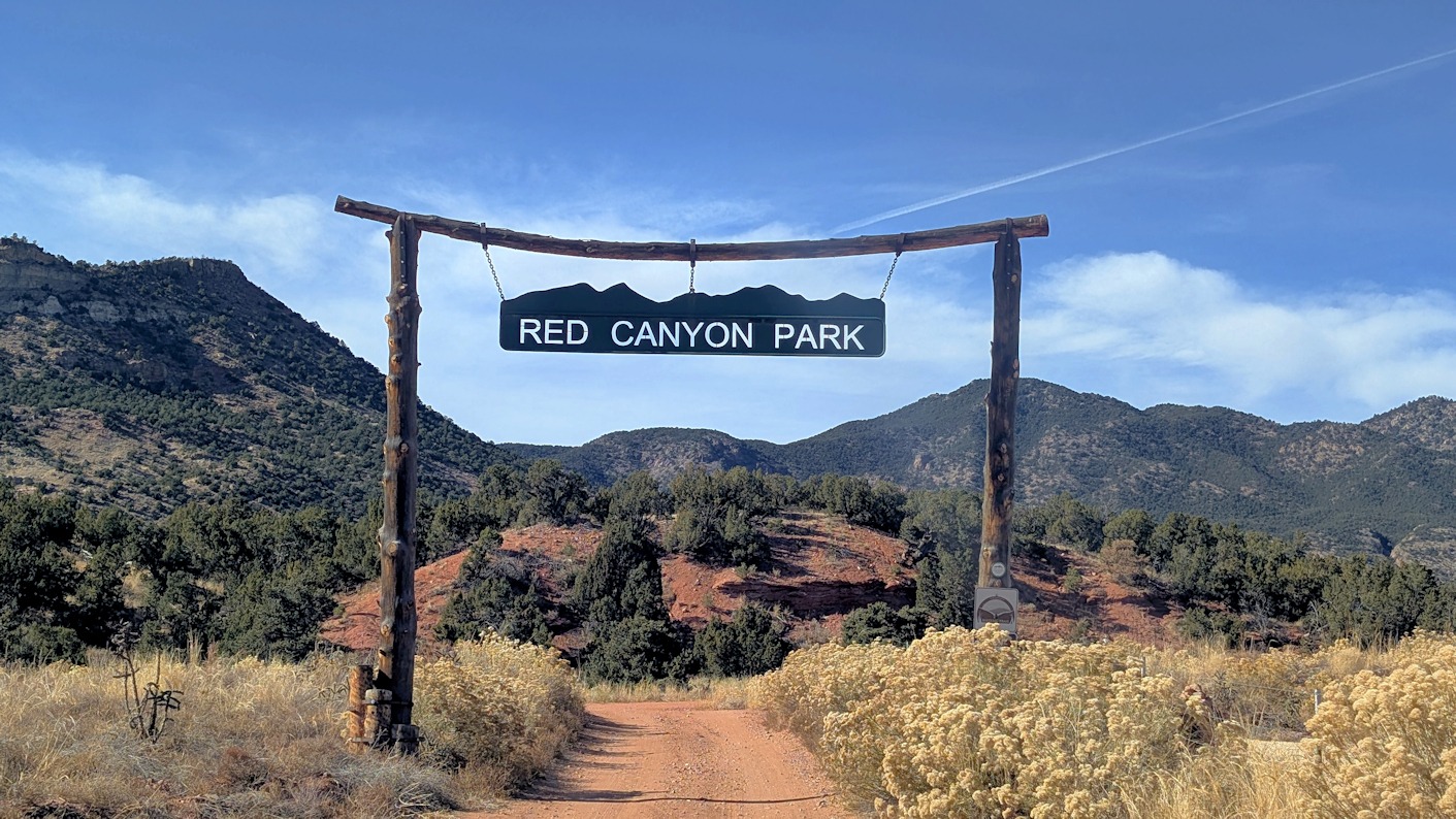
While I was planning a recent hiking trip to Oil Well Flats, I noticed on COTREX (trails.colorado.gov) a plot of land a few miles further north that was labelled as “Red Canyon Park” which was shown to be a Cañon City-owned parcel. The map showed a road running through it and some camping sites, but no trails. Since I was going down to Oil Well Flats anyway, I went to Red Canyon Park and took a drive through it. I didn’t see any trail maps posted but did see trail crossings at various places along the road but, without a map, couldn’t tell if they were part of one long trail, or a bunch of smaller trails, or a combination of both. Without more information, I did my planned hike at Oil Well Flats as planned.
A Google search about Red Canyon Park resulted in some information about the park, the majority of which were several years old and most seemed to indicate that there were no actual trails there, but that it was a beautiful place to visit. Some likened it to Colorado Springs’ Garden of the Gods Park.
I emailed Fremont Adventure Recreation and asked if they had any information about Red Canyon Park and they were kind enough to do some research and send me links to maps located deep in the Cañon City government website. The email also said that they hoped to have the trails there on COTREX soon.
A few days later I returned to Red Canyon Park with a friend and our dogs – leashed dogs are permitted. Armed with printed maps (remember those?) we spent a few hours hiking Chipeta’s Way, a loop trail that goes around the bulk of the park.
We started our hike at a wide spot in the park access road, about 0.8 miles from County Road 9. This spot was also designated as a place for equestrian trailers to park and turn around, as the road gets significantly narrower and shorter immediately after. In fact, on our hike there on a weekend, we did encounter two equestrians and a few other hikers on the trail but noted that the park was otherwise pretty quiet. We could have parked a few hundred feet further up the road at a small parking area adjacent to the trail and a toilet facility.
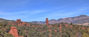
We started our hike on the unmarked south side of the road – there were a couple of wooden posts where presumably signs will be installed – and began doing the loop in a clockwise direction. Much of the park and the trail is composed of soft red sand, and foliage is a wild mix of juniper, fir, wildflowers and at least three different types of cacti, sometimes all jumbled together. The trail offered a mix of shade and open sky, and great views in all directions, including two large sandstone monoliths just to the north. Sadly, those features are outside of the park on private property, behind fences and no trespassing signs. Nonetheless, they are stunning to look at and photograph.
Although some online comments compared the park to the Garden of the Gods, we thought it was more like Colorado Springs’ Red Rock Canyon Open Space. On the north end of the park there is a short loop trail designed for accessibility devices such as Track Chairs or Terrain Hoppers. Parking at that trailhead is limited only to vehicles transporting those devices as there are no facilities at the park to provide the devices.
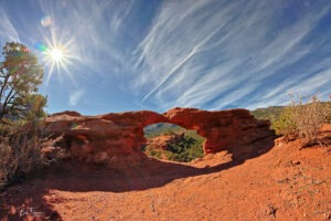
There is a small arch in the park, which is noted on the map, but the short trail to it is not marked with a sign. Alert hikers, however, will have no trouble spotting it.
The trail crosses a large expanse of flat rock high above a narrow canyon, which another visitor described to us as a slot canyon. There is a trail into the slot canyon starting at the trailhead where the pit toilets are located, just past the equestrian parking area where we started. It, too, is unmarked, except for a wooden post, but you’ll have no trouble finding it.
There are trail markers along the trail, and signs asking people to avoid the trails when muddy. The red sandy soil through-out the park is the type that turns into a big muddy mess after it rains or when snow melts, so I’d recommend avoiding the park altogether at those times. Although the road in the park is navigable by anything other than the lowest slung vehicles, some sections are steep and rocky, and cars could get stuck in a position where they can’t get out when conditions are muddy or slick.
Overall, my hiking companion and I agreed that the park is an enjoyable place to hike and deserves a visit. It is a good alternative if nearby Oil Well Flats is too busy for your liking. The total length of our hike was approximately 5 easy miles.
Red Canyon Park is located on Fremont County Road 9/Red Canyon Road about 10.5 miles north of Cañon City, or about 3 miles north of Oil Well Flats. The road to the park is well marked. Google maps provided accurate directions to it by just entering the park name.
As of this writing, the trails in Red Canyon Park are not yet on COTREX, however you can see the park at https://trails.colorado.gov/places/na~2280295.
A map of the park, including the trails, can be found on the Cañon City website.
Special thanks to Fremont Adventure Recreation for their help.
Be Good. Do Good Things. Leave No Trace.